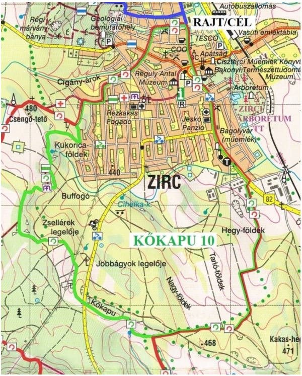
ZIRC30 performance tours - KŐKAPU10
Rout description
Tour length: 9.9 km
Level rise: 220 m
Trail marking:![]()
START/FINISH point: Community centre (Zirc, Alkotmány u. 14.)
KŐKAPU10 – Route description
From the Start Community Centre , we begin our journey on the Alkotmány street towards the town centre and walk to the town’s Southern edge on the odd side of the Rákóczi square – Széchenyi str. – Március 15. square – Kossuth L. str. route.
At the last building on the left, we cross carefully the busy Main Road 82 to the former machine shop’s road where we turn left. On the right side there are shops, industrial halls and a small filling station.
Soon, we reach an unpaved road, arable lands on the right, forest belt on the left. After ca. 600 metres we take a sharp right turn. There is a wildlife fence in front of us; the road goes to the gate.
Turning left, we follow the fence. After the forest belt the road divides. We turn right and walk on the southern side of the forest belt. Up to this point, our route is identical to the route of the Szarvaskút15 tour. We carefully follow the meadow road about 170 metres. The route of the two trails divides here: we walk straight to the level crossing in the forest belt and cross the belt towards the arable lands. 150 metres after the forest belt, we turn uphill to the right, then after 100 metres we reach the Bakonybél main road in Kőkapu, to the left on a wooded and bushy unpaved road. We carefully cross the main road and continue our journey on the unpaved road across.
Following the road, first we see arable lands on the left, but soon we come across to the other side of a forest belt. The belt is on our left side, while grazing land and hayfield on our left. We turn left in a great arch into the woods, where we join the common route of the Rómer Flóris Memorial Trail’ green (Z) path and the Mária trail’s path marked by the purple M. We follow this route until we reach the populated area of Zirc. We follow the joint Z/M in the forest to the north. Reaching a wildlife fence, the route turns right and at its corner to the left. Now, we have to be observant, because we leave the the marked hiking trail to the right on a narrow path which can be hardly noticed. We continue our journey in the woods approx. 150 metres, when the small-leaved lime, which is recorded with its trunk circular measure of 491 m in the list of the biggest tree of Hungary, appears before us.
From this giant tree we follow the path until we reach the forest edge. Here, crossing a hayfield we re-join the Z/M path, which reaches the forest area between the Cornfields (Kukoricaföldek) and the Fairy Farm (Tündérmajor), where the path runs on a section to the north, then turning to the east it descends on the bushy and rocky path above the Cornfields into the Semmelweis street.
Reaching the street, we turn left and meet the hikers arriving from the left, from the Fairy Farm on the Szarvaskút15 trail. From here, we go together to the goal. Our route in the town: Irtás – Eötvös – Szikla – Jókai – Zrínyi – III. Béla street; at the end of the latter we can see the Goal, the Community Centre from afar.