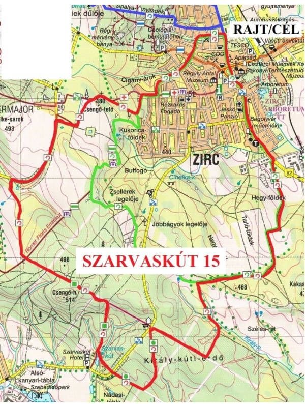
ZIRC30 performance tours - SZARVASKÚT15
Rout description
Tour length: 15,1 km
Level rise: 369 m
Trail marking:![]()
START/FINISH point: Community centre (Zirc, Alkotmány u. 14.)
SZARVASKÚT15 – Route description
From the Start Community Centre , we begin our journey on the Alkotmány street towards the town centre and walk to the town’s Southern edge on the odd side of the Rákóczi square – Széchenyi str. – Március 15. square – Kossuth L. str. route.
At the last building on the left, we cross carefully the busy Main Road 82 to the former machine shop’s road where we turn left. On the right side there are shops, industrial halls and a small filling station.
Soon, we reach an unpaved road, arable lands on the right, forest belt on the left. After ca. 600 metres we take a sharp right turn. There is a wildlife fence in front of us; the road goes to the gate.
We follow the wildlife fence. After the forest belt the road divides. We turn right and walk on the southern side of the forest belt. Up to this point, our route is identical to the route of the KŐKAPU10 tour. We carefully follow the meadow road. After approx. 500 metres the two routes divide: we take a sharp left turn and follow the meadow road downhill (if we see 400 metres across a leaning huge white trunk, we are walking in the right direction).
Soon, to the right we reach the Egyes-, then the Kettes-lake, the spring area of the Király brook. Directly after the Kettes Lake, we start to ascent to half right to the lovely beech forest of the Király well. In a clearance we are heading in SW direction and at a crossing clearance we turn right. We go straight to the Bakonybél main road. Turning left, along the forest edge we follow the red ring trail sign. From here, the sign continues together with the green (Zl) sign. Soon, it enters the forest to the left. We continue our journey along the forest road difficult to walk on. Reaching the clearance, we turn right and descent to the forest road. We turn right and head straight to the Bakonybél main road. We carefully cross the road and take the forest road across slightly to the left. Along a new wildlife fence, we reach the dam of recently cleaned and arranged Szarvas Lake. From here, we can clearly see the green (Zl) sign which also shows the way to the resting spot of the Szarvas well 100 metres away. Read the information boards!
Following the brook’s course, we cross a wooden bridge and reach a forest road. Turning to the left, we follow first the green square (Zl)/green point (Zl) signs. The Zl path will soon leave us, while the Zl leads us dowhill to the Csengő Hill, then downhill in a bee-line to the joint route of the Rómer Flóris Memorial Trail’s green (Z) path and the Mária Trail’s path marked by a purple M. We follow the joint section of Z/M only approx. 60 metres to the left. Then we take a sharp turn to right. Walking between arable lands on our left and a shrub belt on the right, we reach the bend of the gravel road leading to Pálinkaház. We turn right and climb on the gravel road to the Fairy Farm. We can see a horse ranch to the right and a fenced pond. Leaving behind the pond’s fence, we turn right to the gravel road. After approx. 220 m, after a family house on the left side we turn left in the meadow and head toward the hydro globe visible in the distance.
Here, we meet the red plus (P+) sign which accompany us only on a short section. We descend on the ‘usual’ lovely road into the Irtás street where the route of the KŐKAPU10 trail re-joins us from the Semmelweis street, from where we go toghether to the goal. Our route in the town: Irtás – Eötvös – Szikla – Jókai – Zrínyi – III. Béla street; at the end of the latter we can see the Cgoal, the Community Centre from afar.